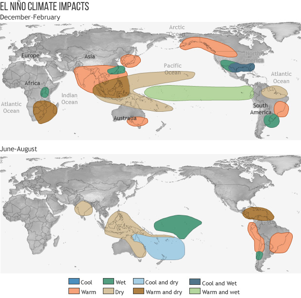
The start of the Atlantic hurricane season coincides with forecasters predicting a quieter-than-usual year. A trend heavily influenced by the El Niño weather phenomenon. The US National Oceanic and Atmospheric Administration (NOAA) has estimated a 55 percent chance of below-normal storm activity in the Atlantic Basin for the year. This shift is driven by the periodic warming of surface sea temperatures. Both in the central and eastern tropical Pacific Ocean, which disrupts global wind and rainfall patterns. While hurricanes, cyclones, and typhoons are essentially the same type of severe storm system. Therefore defined by wind speeds exceeding 119 kilometers per hour (74 miles per hour)—their geographic locations dictate how El Niño alters their behavior.
Historically, El Niño events trigger a 60 percent reduction in Atlantic hurricane days and decrease overall storm intensity. Despite these favorable odds, weather officials warn that it only takes a single storm to cause a catastrophic season. Noting that Atlantic hurricanes remain some of the deadliest and costliest natural disasters, responsible for over 7,200 deaths and 1.55 trillion dollars in US economic losses between 1980 and 2024. In contrast to the Atlantic, El Niño tends to increase storm activity in the Northeast Pacific around Hawaii. Especially in the year immediately following the phenomenon’s onset.
In other parts of the world, El Niño reshapes rather than completely stops tropical storms. Across Australia and the South Pacific, fewer storms form along the Australian coastline because the active storm-generation zone shifts eastward toward the international dateline. A similar pattern occurs in Asia and the Northwest Pacific. While the total number of typhoons remains relatively steady, fewer form in the western Pacific near the Asian mainland, with more developing further east. Meanwhile, the southwestern and northern Indian Oceans see little to no change in their typical storm patterns during this climate phase.
To help communicate these risks and streamline public warnings, meteorologists utilize standardized naming conventions managed by the World Meteorological Organization. Storms receive names alternating between male and female choices from rotating six-year lists. If a tropical system proves exceptionally deadly or destructive—such as Katrina, Sandy, Irma, or Maria—its name is permanently retired from the rotation. In order to preserve historical clarity and ensure future safety warnings remain clear to local populations.
Ultimately, while El Niño acts as a powerful global climate regulator by reducing the overall number and intensity of Atlantic hurricanes. Furthermore, it simultaneously shifts storm activity to other regions, such as the Northeast and central Pacific. Highlighting that severe weather risks are rearranged rather than eliminated. Because even a single anomalous storm can cause catastrophic human and economic losses. In conclusion, meteorologists rely on tools like standardized naming systems to maintain clear safety warnings. Emphasizing that global readiness remains essential regardless of seasonal forecasts.
Reference
Ali, M. (2026, June). How could El Nino reshape tropical storms around the world this year? Al Jazeera. https://www.aljazeera.com/news/2026/6/1/how-could-el-nino-reshape-tropical-storms-around-the-world-this-year