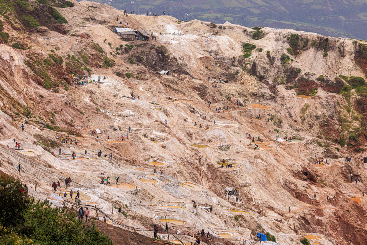
Since the beginning of 2026, at least four massive landslides have struck the Rubaya mining area in the Democratic Republic of the Congo (DRC). This being a critical global source of coltan used in electronics and electric vehicles. The disaster zone is currently under the control of the Rwandan-backed rebel group M23, which restricts access for journalists and NGOs. This lack of ground access, combined with frequent cellular network outages, has made tracking the true human toll incredibly difficult. To uncover what happened, Bellingcat (the investigation source) utilized open-source tools, satellite imagery, and geolocated social media footage to verify the scale of the disasters and investigate conflicting political narratives.
The first landslide occurred on January 28, 2026, and was reported to have killed over 200 people. The DRC government blamed the tragedy on illegal mining operations run by M23 and Rwanda. While the M23-appointed local governor instead attributed it to heavy seasonal rains. Bellingcat successfully geolocated distance footage from a mining pit southeast of Rubaya. Therefore, used satellite comparison data to map the path of the mud as it advanced down the slope.
In addition, a second landslide hit the exact same location on March 3, 2026. The DRC Ministry of Mines posted a provisional death toll exceeding 200 people. However, a senior M23 official publicly denied that any landslide took place, claiming the casualties were minimal and caused by military bombings elsewhere. The investigation directly contradicted this denial. Researchers verified and geolocated close-up social media videos showing extensive community-led rescue operations. Where residents were digging through mud and pulling out dead bodies, with no evidence or eye-witness accounts supporting the claim of a bombing.
Just four days later, on March 7, 2026, a third landslide devastated a village southwest of Rubaya. Civil society officials reported that mud entirely swallowed the homes of more than 40 families, killing over 300 people. Bellingcat analyzed and verified over a dozen highly distressing local media videos from the scene, identifying the bodies of young children who were caught in their beds. Satellite analysis confirmed a massive east-to-west mud surge in the area. At final, smaller landslide was documented on March 27, 2026, back at the site of the first two disasters, which collapsed two mining shafts and killed at least nine workers.
In conclusion, beyond verifying the environmental tragedies, the investigation exposed misinformation stemming from the broader geopolitical conflict. DRC Government Spokesman Patrick Muyaya shared a video on social media that claimed to show open-source satellite evidence of expanding mine exploitation under rebel control. However, fact-checking revealed that the video was fabricated by a local Facebook page. By utilizing old Google Earth imagery from 2019 while falsely appending external verification and Planet Labs watermarks to it. Ultimately, neither M23 nor the DRC government responded to requests for updated casualty counts, leaving thousands of low-wage miners to navigate deadly, unmonitored conditions.
Reference
Riccardo, A. (2026, May 12). DRC’s Coltan Belt: Verifying Deadly Landslides at Mines Under M23 Control – bellingcat. Bellingcat. https://www.bellingcat.com/news/africa/2026/05/12/congos-coltan-belt-verifying-deadly-landslides-at-mines-under-m23-control/