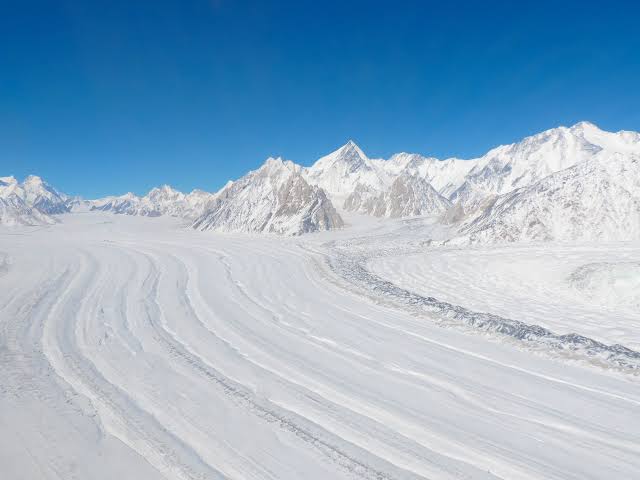
The Siachen Glacier, a 70-kilometer stretch of ice in the Karakoram mountain range, remains the world’s highest and most unforgiving battlefield. Despite a comprehensive truce reached between India and Pakistan in May 2025 following a brief missile and drone war. Thousands of soldiers from both nations remain deployed along the treacherous Saltoro Ridge at elevations approaching 8,000 meters. The conflict over this region has acquired a unique, persistent logic. While a formal ceasefire has prevented direct combat deaths since November 2003. The environment itself continues to claim lives, making nature the primary adversary for both militaries.
Fewer than 3 percent of the more than 2,000 casualties recorded since the conflict began in 1984 are the result of actual combat. Instead, soldiers regularly succumb to extreme sub-zero temperatures. Plunging to minus 50 degrees Celsius, high-altitude blizzards moving at 300 kilometers per hour, severe oxygen deprivation, bottomless crevasses, and catastrophic avalanches. For instance, a massive ice wall collapse in 2016 buried ten Indian soldiers at Sonam Post. Sparking a dramatic but ultimately fatal rescue attempt. Similarly, a colossal avalanche in 2012 destroyed a Pakistani military base in the Gayari sector. Swallowing 1.2 square kilometers under deep ice and killing 140 people.
The financial and environmental costs of sustaining this frozen standoff are immense and unsustainable for both developing nations. India’s high-altitude logistics require importing a significant portion of its specialized gear. With a decade-old annual budget benchmark exceeding $499 million. Pakistan faces a comparable multi-million-dollar burden to equip thousands of troops despite deep domestic economic strain and IMF bailouts. Furthermore, the military presence severely degrades the glacier. As nearly 900 kilograms of human waste are dumped daily into crevasses alongside toxic heavy metals from artillery. This chemical pollution directly threatens the Indus River system, which is fed by the glacier’s meltwater. Compounding this, recent studies indicate the glacier is shifting toward a net mass loss due to climate change. Meaning both nations are actively funding an expensive war over a rapidly disappearing geographical asset.
The roots of the dispute trace back to the 1949 Karachi Agreement following the partition of British India. UN cartographers drew a Ceasefire Line that ended abruptly at a map grid coordinate known as NJ 9842. Assuming the terrain beyond was too inhospitable for human life. The agreement vaguely stated that from this point, the boundary would simply run “thence north to the glaciers”. Leaving a 60-to-70-kilometer gap undemarcated up to the Chinese border. This ambiguity turned into a geopolitical flashpoint in April 1984. When India launched Operation Meghdoot to preemptively occupy the glacier’s strategic passes. Prompting Pakistan to establish counter-positions along the ridge lines and cementing decades of militarization.
In conclusion, the ongoing standoff on the Siachen Glacier is a war of attrition. Against the lethal mechanics of high-altitude geography rather than an enemy army. As climate change begins to melt the very territory both nations are fighting to possess. The ecological and human toll increases while its strategic value diminishes, presenting a shared threat that far outweighs any territorial gain.
Reference
Hussain, A. (2026, June 12). Mountain of war: The India-Pakistan conflict’s deadliest battle zone. Al Jazeera. https://www.aljazeera.com/news/longform/2026/6/12/mountain-of-war-the-india-pakistan-conflicts-deadliest-battle-zone